Augmented reality is transforming smart cities by overlaying digital information onto real environments, helping planners, engineers, and citizens visualize infrastructure, analyze live data, and participate in urban development. AR enhances urban planning through improved visualization, real-time sensor integration, participatory engagement, and cost savings.
As cities around the world strive for sustainability, efficiency, and citizen inclusivity, technology plays a pivotal role in shaping tomorrow’s urban environments. Augmented reality (AR) is emerging as a game-changer for smart cities, offering planners, engineers, and residents immersive tools to visualize, analyze, and co-create public spaces in real time. In this article, we explore how AR is revolutionizing urban planning and citizen engagement, examine real-world use cases, discuss benefits and challenges, and look ahead to future trends.
What Is AR in the Context of Smart Cities?

Augmented reality layers digital information—3D models, data feeds, annotations—onto the physical world. Unlike virtual reality, which creates a fully digital environment, AR enhances existing cityscapes through smartphones, tablets, smart glasses, or head-mounted displays. For smart city initiatives, AR can unlock new possibilities to:
- Visualize infrastructure projects before construction begins
- Overlay real-time sensor data (traffic, pollution, energy usage)
- Facilitate remote collaboration among architects, engineers, and officials
- Engage citizens through interactive planning workshops
Key Benefits of AR-Enabled Urban Planning
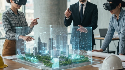
1. Enhanced Visualization
Traditional blueprints and 2D renderings can be abstract for non-technical stakeholders. AR brings plans to life by projecting 3D building designs, park layouts, or transit routes directly onto current sites. This clarity accelerates decision-making and reduces costly revisions later in the process.
2. Participatory Engagement
AR apps enable citizens to point their devices at a proposed plaza or bike lane and see the planned changes overlayed on their screen. They can submit feedback, vote on design options, or even sketch ideas in situ. This democratic approach fosters transparency and builds public trust.
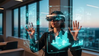
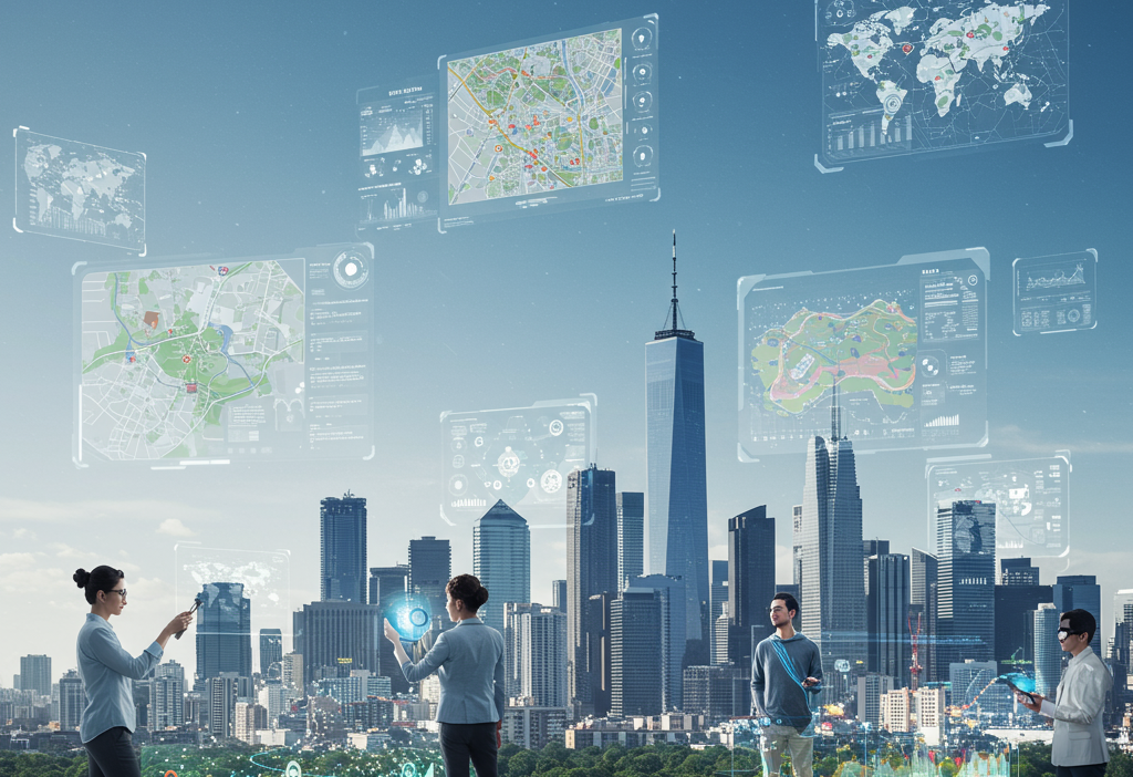
3. Real-Time Data Integration
Smart city sensors—monitoring air quality, traffic density, noise levels—feed live data into AR visualizations. Planners can identify congestion hotspots, predict pollution trends, or optimize energy consumption in public buildings with an intuitive, geo-anchored interface.
4. Cost and Time Savings
By detecting design clashes early and enabling virtual site walk-throughs, AR reduces the need for physical mockups and multiple on-site visits. Projects stay on schedule and within budget, freeing resources for other community priorities.
Real-World Use Cases
Smart Dubai’s Virtual City Model
The Smart Dubai initiative created an AR app that overlays Dubai’s 3D city model onto actual streets. Residents and tourists can explore upcoming developments, traffic updates, and cultural landmarks. Planners use the same platform to test road expansions and green space allocations in context.
Helsinki’s Citizen-Centric Workshops
In Helsinki, AR stations in public libraries allow citizens to review proposed parking regulations and building guidelines. Users wear headsets to place virtual structures on physical lots, instantly grasping the scale and sightlines. Their feedback directly informs municipal zoning decisions.
Sidewalk Labs’ Waterfront Redevelopment
At Toronto’s Quayside project, Sidewalk Labs tested AR visualization tools for sustainable design workflows. Stakeholders could simulate pedestrian flows, test daylight access, and experiment with modular street furniture, all through a tablet-based AR interface.
Challenges and Considerations
1. Data Privacy and Security
AR systems often require geolocation and camera access, raising privacy concerns. Cities must enforce strict data governance policies, anonymize user inputs, and store sensitive infrastructure plans in secure environments.
2. Technical Infrastructure
High-precision AR demands accurate mapping, reliable 5G or Wi-Fi connectivity, and up-to-date digital twins of city assets. Legacy systems may need upgrades to support seamless AR experiences.
3. Digital Divide
Not all residents have access to AR-capable devices, risking exclusion of lower-income or elderly populations. Municipalities can address this by deploying AR kiosks, lending programs, or community workshops to ensure broad participation.
AR for Emergency Response and Public Safety

Augmented reality is becoming an essential tool for enhancing emergency response strategies in smart cities. AR overlays critical information—such as building layouts, hazard zones, evacuation paths, and real-time sensor alerts—directly onto physical locations. Firefighters can use AR helmets to see structural weaknesses or gas leak indicators, allowing them to navigate dangerous environments with more accuracy. Police and rescue teams can visualize crowd density during major events, enabling faster, more coordinated actions. Additionally, AR assists in search-and-rescue missions by highlighting heat signatures, victim locations, or blocked routes. This integration of situational awareness reduces response time, minimizes casualties, and strengthens overall urban resilience, making cities safer and better prepared for crisis scenarios.
AR for Transportation Planning and Smart Mobility
Transportation networks are the backbone of modern cities, and AR is transforming the way planners visualize and optimize mobility systems. Through AR-driven overlays, engineers can simulate traffic flows, evaluate the impact of new bus lanes or bike paths, and test rerouting strategies before implementation. Pedestrians and commuters can use AR navigation apps to view live transit schedules, crowd levels, and route recommendations directly in their field of vision. Maintenance crews benefit from AR-enabled diagnostics that identify faulty components in traffic lights, rail systems, or road infrastructure. As autonomous vehicles become more common, AR will also assist with vehicle-to-infrastructure communication, enabling safer, more efficient mobility ecosystems. This comprehensive approach enhances accessibility, reduces congestion, and improves overall travel experiences for citizens.
AR for Environmental Monitoring and Sustainability
Sustainability is a priority for smart cities, and AR helps visualize ecological health in intuitive ways. Environmental scientists and urban planners can overlay data about carbon emissions, water usage, heat islands, and biodiversity hotspots directly onto real-world locations. AR makes hidden environmental dynamics visible—for instance, showing how polluted air disperses through a neighborhood or how tree planting could reduce temperature extremes. Citizens can use AR apps to scan parks, rivers, or recycling stations to learn about ecological conditions or sustainable practices. AR also supports climate adaptation planning by simulating flood levels, storm impacts, or erosion patterns, helping cities prepare for environmental risks. By transforming abstract sustainability data into tangible experiences, AR fosters awareness and encourages collective responsibility.
AR for Cultural Preservation and Tourism
Cities rich in history and culture are leveraging AR to preserve heritage and enhance tourism engagement. Visitors can point their devices at ruins, monuments, or historical streets to view reconstructed 3D models showing how the area looked centuries ago. AR can animate ancient marketplaces, show historical figures in context, or provide immersive storytelling experiences in multiple languages. Museums and heritage sites use AR-guided tours to deliver interactive content that adapts to user interests. For cities, AR adds value without requiring new physical infrastructure, allowing them to modernize cultural engagement while preserving authenticity. This fusion of past and present deepens cultural appreciation, boosts tourism revenue, and helps younger generations learn in more immersive and memorable ways.
AR for Education and Community Learning
Education within smart cities is evolving as AR brings complex concepts to life through immersive visualization. Students can walk through virtual solar systems, interact with geometric structures overlaid on classroom floors, or explore historical events reconstructed right in front of them. Community learning centers can use AR to teach residents about civic services, environmental goals, or local history. In vocational training, AR enables interactive simulations—for example, teaching electricians how to install wiring, or medical trainees how to perform basic procedures with holographic overlays. This form of experiential learning bridges the gap between theory and practice, empowering citizens with new skills and boosting long-term workforce development. AR-driven education contributes to more knowledgeable, capable, and engaged communities.
AR for Retail, Commerce, and Economic Growth
Smart cities are increasingly adopting AR to strengthen economic activity and reshape how citizens shop and interact with local businesses. Retailers can create AR storefronts where shoppers preview products in real environments—such as placing furniture in their homes, trying on virtual clothing, or testing appliances. Local markets can enhance visibility with AR-based product details, sustainability scores, or price comparisons. For city planners, AR provides insights into commercial foot traffic, helping optimize zoning and business district layouts. Entrepreneurs can use AR pop-up shops to reduce physical retail costs while reaching broader audiences. AR payments and navigation systems streamline the shopping process, making urban commerce more efficient. By bridging digital experiences with physical retail, cities foster economic growth and enhance customer satisfaction.
Future Trends

1. Immersive Digital Twins
Next-generation digital twins will combine AR with real-time IoT feeds, AI-driven simulations, and predictive analytics. Urban managers could foresee traffic snarls before they happen or optimize emergency response routes on the fly.
2. Wearable AR and Smart Glasses
As head-mounted displays become lighter and more affordable, planners and citizens will enjoy hands-free AR interactions. On-site construction crews can follow step-by-step holographic instructions, reducing errors and training time.
3. Mixed Reality Collaboration
By blending AR with real-time holographic telepresence, remote experts can join on-site meetings as lifelike avatars. Cross-disciplinary teams across continents will iterate on designs together, speeding up innovation cycles.
4. Gamified Urban Planning
Some cities are exploring AR games that let residents earn points by reporting infrastructure issues or proposing green initiatives. Gamification boosts engagement, turning civic participation into an interactive, rewarding experience.
Conclusion
Augmented reality is more than a flashy demo—it’s a practical, cost-effective tool for creating more transparent, inclusive, and resilient cities. By visualizing future developments in situ, integrating live data, and empowering citizens to shape their surroundings, AR paves the way for smarter urban ecosystems. As technical infrastructures mature and privacy safeguards strengthen, the potential for AR-driven smart cities will only continue to expand, building a bridge between digital innovation and everyday life.
FAQ: Augmented Reality in Smart Cities
1. What is augmented reality (AR) in the context of smart cities?
AR overlays digital information, such as 3D models, data feeds, and annotations, onto the real world using smartphones, tablets, or smart glasses. Unlike virtual reality, which creates a fully digital environment, AR enhances existing cityscapes to help planners, engineers, and citizens visualize infrastructure, analyze data, and interact with public spaces.
2. How does AR benefit urban planning?
AR improves visualization of infrastructure projects, facilitates citizen participation, integrates real-time data for informed decisions, and reduces costs and time by enabling virtual site walkthroughs. It helps stakeholders understand designs intuitively and minimizes costly revisions.
3. Can citizens participate in planning through AR?
Yes. AR allows residents to see proposed changes in situ, submit feedback, vote on design options, or sketch ideas directly on their devices. This participatory approach increases transparency, encourages community engagement, and builds public trust.
4. What real-world examples exist of AR in cities?
Examples include Smart Dubai’s AR city model for exploring developments and testing infrastructure, Helsinki’s AR workshops for citizen feedback on zoning and parking, and Toronto’s Sidewalk Labs using AR to simulate sustainable urban design scenarios at Quayside.
5. What are the main challenges of AR implementation in cities?
Key challenges include data privacy and security concerns, the need for high-precision technical infrastructure like 5G and updated digital twins, and the digital divide, where some residents lack access to AR-capable devices. Cities must address these issues to ensure safe and inclusive participation.
6. How does AR integrate with real-time city data?
AR can pull live data from smart city sensors—traffic, air quality, noise, and energy use—and overlay it on physical spaces. This allows planners to identify congestion, predict pollution trends, or optimize public resources interactively and intuitively.
7. What future trends are expected for AR in smart cities?
Future trends include immersive digital twins combining AR with AI and IoT data, wearable AR and smart glasses for hands-free interactions, mixed-reality collaboration for remote experts, and gamified urban planning to encourage citizen participation and feedback.
8. How can AR reduce costs in urban projects?
By detecting design clashes early, allowing virtual walkthroughs, and minimizing the need for physical mockups or repeated site visits, AR helps projects stay on schedule, reduces errors, and frees up resources for other city priorities.
9. Is AR accessible to all residents?
Accessibility remains a challenge. Cities can deploy AR kiosks, lending programs, or community workshops to ensure equitable participation, especially for lower-income or elderly populations who may not own AR-capable devices.
10. Why is AR considered a practical tool for smart cities?
AR provides immersive, interactive, and real-time insights into urban spaces. It empowers both officials and citizens to make informed decisions, increases engagement, and supports transparent, sustainable, and resilient urban development.