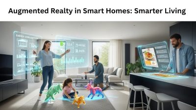
Augmented reality (AR) is transforming urban planning by overlaying digital information onto real-world environments, allowing planners, architects, and stakeholders to visualize developments in real time. AR enhances collaboration by turning 2D blueprints and 3D models into immersive experiences, enabling real-time feedback, design annotations, and clearer communication.
Augmented reality (AR) is rapidly reshaping how we envision and construct our cities. By overlaying digital information onto the physical environment, AR enables urban planners, architects, and stakeholders to visualize proposed developments in real time, improving communication and decision-making. In an era where cities face growing populations, climate challenges, and evolving transportation needs, AR offers a powerful toolkit for designing more efficient, sustainable, and inclusive urban landscapes.
Enhancing Visualization and Collaboration
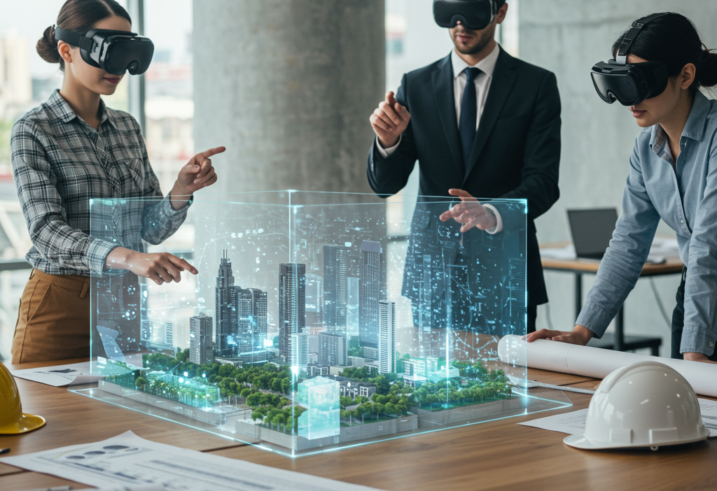
One of the primary benefits of AR in urban planning is its ability to bring 2D blueprints and 3D models into the real world. Stakeholders can walk through proposed streetscapes and public spaces wearing AR glasses or using mobile devices, gaining a lifelike sense of scale, materials, and context. This immersive approach bridges the gap between technical drawings and lived experience, facilitating clearer feedback from community members, city officials, and investors. Real-time annotations allow teams to mark up designs collaboratively, reducing errors and streamlining approval processes.
Real-Time Simulation of Traffic and Environment

Beyond static renderings, AR can simulate dynamic elements such as traffic flow, pedestrian movement, and environmental conditions. By integrating real-time data feeds from sensors and traffic management systems, planners can visualize peak congestion points, test new bike lane configurations, or evaluate how a new high-rise might cast shadows on public parks. These simulations aid in proactive problem solving, helping cities mitigate traffic bottlenecks, improve safety, and optimize public transit routes before any ground is broken.
Engaging Communities Through Interactive Planning
Meaningful public engagement is essential for successful urban development, yet traditional town halls often fail to convey complex design proposals. AR transforms community meetings into interactive experiences: residents can use tablets or their own smartphones to view proposed playgrounds, plazas, or housing projects superimposed onto their neighborhood streets. This tangible interaction fosters a sense of ownership and transparency, encouraging broader participation and reducing the risk of costly redesigns due to overlooked community concerns.
Integrating Data: IoT, GIS, and Beyond
Smart cities rely on vast networks of sensors, GIS databases, and Internet of Things (IoT) devices to monitor everything from air quality to energy use. AR acts as a unifying interface, visualizing these data streams directly on the urban canvas. For instance, a planner might point an AR-enabled tablet at a building facade to see real-time energy consumption metrics, or survey a street to identify sub-surface utility lines before excavation. By merging spatial analytics with immersive overlays, AR enhances situational awareness and fosters data-driven decision-making at every stage of the planning lifecycle.
Challenges and Considerations
While the potential of AR in urban planning is immense, several challenges must be addressed. High-resolution 3D mapping and accurate geolocation require robust hardware and connectivity, which can be costly to deploy citywide. Data privacy and security are paramount when integrating citizen-generated feedback and sensor networks. Additionally, urban planners must navigate regulatory frameworks and accessibility standards to ensure AR tools serve all community members equitably. Overcoming these hurdles will demand close collaboration between technology providers, municipal governments, and civil society.
AR-Driven Urban Mobility Planning

AR allows city planners to superimpose proposed transportation networks—including bike lanes, pedestrian pathways, bus routes, and ride-sharing hubs—onto the existing urban fabric. By simulating traffic flows, peak-hour congestion, and pedestrian movement, AR enables planners to anticipate bottlenecks and optimize mobility solutions before construction begins. Planners can also test the impact of new infrastructure on traffic safety, commute times, and accessibility for differently-abled users. This reduces costly trial-and-error in mobility design and promotes sustainable, efficient urban transportation, while fostering integration with future technologies like autonomous vehicles and smart traffic management systems.
Environmental Impact Visualization
AR empowers urban planners to visualize the ecological consequences of proposed developments directly on the landscape. By overlaying data such as stormwater runoff patterns, solar exposure, air pollution levels, noise maps, and heat islands, planners can identify and mitigate environmental risks early. AR also allows for the simulation of green infrastructure, such as rooftop gardens, permeable pavements, or tree planting initiatives, to assess their effectiveness in real time. This immersive approach ensures sustainable urban design decisions, reduces carbon footprints, and supports cities in achieving climate resilience goals while balancing development and environmental preservation.
Historical Preservation and Cultural Layering
Integrating AR into urban planning ensures that new developments coexist harmoniously with historic sites and cultural landmarks. Planners can overlay 3D reconstructions of heritage buildings, monuments, or culturally significant streetscapes on real-world environments to assess the visual and functional impact of proposed projects. AR can also animate historical timelines, showing past urban layouts to inform design choices that respect cultural context. By preserving architectural heritage and fostering cultural continuity, AR helps maintain a city’s identity while enabling modern growth, ensuring that urban expansion does not erase historical and community value.
Emergency Response and Disaster Planning
AR enables city planners and emergency management teams to simulate natural disasters, accidents, or infrastructural failures in a realistic urban environment. By overlaying flood zones, earthquake-prone areas, fire paths, and emergency evacuation routes onto the city map, AR allows planners to proactively design mitigation strategies and emergency response protocols. First responders can use AR to visualize the safest routes, locate resources, and coordinate rescue operations more effectively. This forward-looking approach increases urban resilience, reduces human and economic losses during emergencies, and provides citizens with safer, more prepared communities.
AR-Enhanced Construction Management
During construction, AR transforms traditional project management by overlaying digital blueprints and 3D models directly onto the physical site. Contractors, engineers, and architects can visualize structural components, identify errors, and ensure that installations match design specifications. AR also enables remote monitoring, allowing teams to conduct virtual inspections, detect misalignments, and monitor safety compliance in real time. This minimizes costly delays, reduces material waste, enhances coordination among stakeholders, and ensures projects are completed efficiently while maintaining design integrity and structural accuracy.
Mixed-Use Development Planning

AR provides planners and developers with an immersive tool to model complex, mixed-use projects that combine residential, commercial, recreational, and public spaces. By visualizing human movement patterns, sunlight exposure, building density, and social interaction zones, AR allows designers to optimize livability, accessibility, and comfort. Planners can simulate scenarios such as foot traffic flow during peak hours, crowd behavior during events, or integration of public transport with commercial hubs. This ensures that new developments enhance community experience, create vibrant public spaces, and avoid unintended issues like congestion, shadowing, or underutilized areas.
Citizen-Centric Feedback and Participatory Design
AR transforms urban planning into a collaborative, citizen-driven process. Residents can explore proposed projects using smartphones, tablets, or AR glasses, leave digital annotations, vote on design options, or suggest improvements in real time. This interactive participation fosters transparency, builds trust, and ensures community needs and preferences are incorporated into the final design. By capturing real-world user input and visualizing its impact instantly, planners can make better-informed decisions, reduce costly revisions, and strengthen the social and functional relevance of urban projects, creating cities that truly reflect their inhabitants’ needs.
AR-Powered Economic and Commercial Analysis
AR allows planners and developers to evaluate the economic feasibility and commercial potential of urban projects in an interactive environment. Retail zones, office spaces, entertainment districts, and marketplaces can be virtually mapped and tested for factors such as pedestrian traffic, visibility, accessibility, and footfall patterns. AR simulations help stakeholders forecast revenue potential, assess competitor presence, and optimize spatial arrangements for maximum engagement. By integrating predictive analytics and behavioral insights, cities can attract investments, support local economies, and ensure that urban development delivers both financial viability and improved community services.
Future Trends and Innovations

The next wave of AR development promises even deeper integration with artificial intelligence and edge computing. Vision-based machine learning models will automatically detect structural issues or compliance violations during site inspections, overlaying corrective guidance in real time. Haptic feedback gloves could allow users to feel textures of proposed materials, while brain-computer interfaces may one day enable gesture-free control of urban simulations. As 5G and low-Earth-orbit satellite networks expand, AR experiences will become more seamless, scalable, and accessible to smaller municipalities worldwide.
Best Practices for Municipal Implementation
Cities looking to adopt AR should begin with pilot projects focused on high-impact areas such as public transit hubs or major redevelopment sites. Establishing open data standards and interoperable platforms ensures that AR applications can integrate with existing GIS and asset management systems. Training programs for planners, engineers, and community leaders will accelerate adoption and demonstrate tangible ROI. Finally, transparent dialogue with residents about data use, privacy safeguards, and project goals will build trust and unlock the full potential of AR for urban transformation.
Conclusion
Augmented reality is more than a futuristic gimmick—it is a transformative force in urban planning and smart city development. By enhancing visualization, enabling real-time simulations, and fostering inclusive community engagement, AR helps cities design with precision, efficiency, and empathy. As technology matures and integration deepens, municipal leaders who embrace AR will be better equipped to tackle the complex challenges of rapid urbanization, climate resilience, and social equity, building the sustainable, vibrant cities of tomorrow.
FAQ: Augmented Reality in Urban Planning
1. What is augmented reality (AR) in urban planning?
AR in urban planning overlays digital models and information onto the physical environment, allowing planners, architects, and stakeholders to visualize proposed developments in real time. It bridges the gap between technical drawings and the real-world context.
2. How does AR enhance visualization and collaboration?
AR brings 2D blueprints and 3D models into an immersive environment. Stakeholders can explore proposed streetscapes or public spaces, annotate designs collaboratively, and provide feedback directly within the AR interface, improving communication and reducing design errors.
3. Can AR simulate real-world conditions like traffic or the environment?
Yes. AR can integrate live data from sensors and traffic systems to simulate traffic flow, pedestrian movement, environmental factors, and even shadow impacts. This enables planners to test and optimize designs before construction begins.
4. How does AR engage communities in planning?
AR transforms public meetings into interactive experiences. Residents can view proposed developments superimposed onto their neighborhoods using smartphones or tablets, fostering transparency, ownership, and higher participation in planning decisions.
5. What types of data can AR integrate?
AR can visualize IoT sensor data, GIS databases, energy consumption metrics, utility lines, and other spatial analytics. It acts as a unifying interface to merge data streams with the urban environment for better situational awareness and decision-making.
6. What are the challenges of using AR in cities?
Challenges include high costs for high-resolution 3D mapping and AR hardware, connectivity requirements, data privacy concerns, and ensuring accessibility and regulatory compliance. Effective implementation requires collaboration between technology providers, governments, and communities.
7. How is AR expected to evolve in urban planning?
Future trends include integration with AI for automated detection of design issues, haptic feedback for tactile simulations, gesture-free controls via brain-computer interfaces, and more seamless experiences through 5G and satellite networks.
8. What are best practices for cities adopting AR?
Start with pilot projects in high-impact areas, establish open data standards, ensure interoperability with GIS systems, provide training for planners and stakeholders, and maintain transparent communication with the community about data use and project goals.
9. Is AR suitable for all urban planning projects?
AR is most effective for projects that benefit from visualization and public engagement, such as public spaces, transit hubs, large-scale redevelopment, and infrastructure projects. Smaller-scale projects may also benefit, depending on resources and objectives.
10. What is the ultimate benefit of AR in urban planning?
AR enhances decision-making, collaboration, and community engagement. It allows cities to design efficiently, anticipate challenges, and create sustainable, inclusive, and resilient urban environments.